Wednesday, February 20, 2013

Columbia Falls and Hungry Horse, Montana


Hungry Horse ReservoirA few minutes south of Whitefish is the turn off to Columbia Falls, directly east on Montana Highway 40. (You can also go straight south to Kalispell, but that'll be a discussion for another time.)
 
After my friend, Shannan (again, mentioned often in previous blogs), moved from Eureka, her family moved to Columbia Falls. We had so much fun there, but mostly just "being".
 
But other than just "being", the Columbia Falls' Chamber of Commerce's website list some other fun things that you can actually do there are:
This time, we drove straight through to Hungry Horse...after stopping for groceries, that is. And, actually - now that I brought that up - this particular grocery store (I think it was Super 1 Foods) had the most beautiful fruit display I've ever seen. (I'm not saying they had the most variety or the most exotic fruit, but their displays were really beautifully laid out. In fact, they even had a really pretty onion display! I took so many pictures, I'm pretty sure they thought I was a "secret shopper".)
Onion displayFruit Display
Seven miles (11 kms) further east, on your way to Glacier National Park, you will find Hungry Horse.
 
As the name suggests, Hungry Horse was named after two hungry horses, Tex and Jerry. Apparently, in the winter of 1900, Tex and Jerry wandered away, but were found a month later, hungry and scrawny, but alive!
 
Although Hungry Horse is only 11 miles (18 kms) from Glacier National Park, we didn't quite get there... we spent our entire weekend in Hungry Horse and the Hungry Horse Dam area.
 
Even though I grew up not that far away (see Eureka, MT blog), I had never been to Hungry Horse (except passing through on my way to Glacier) and we (ok, I) decided it was time to change that. So, when a couple of our friends from Calgary wanted to go "somewhere new, somewhere sunny", for August Long Weekend, we (ok, I) picked Hungry Horse.
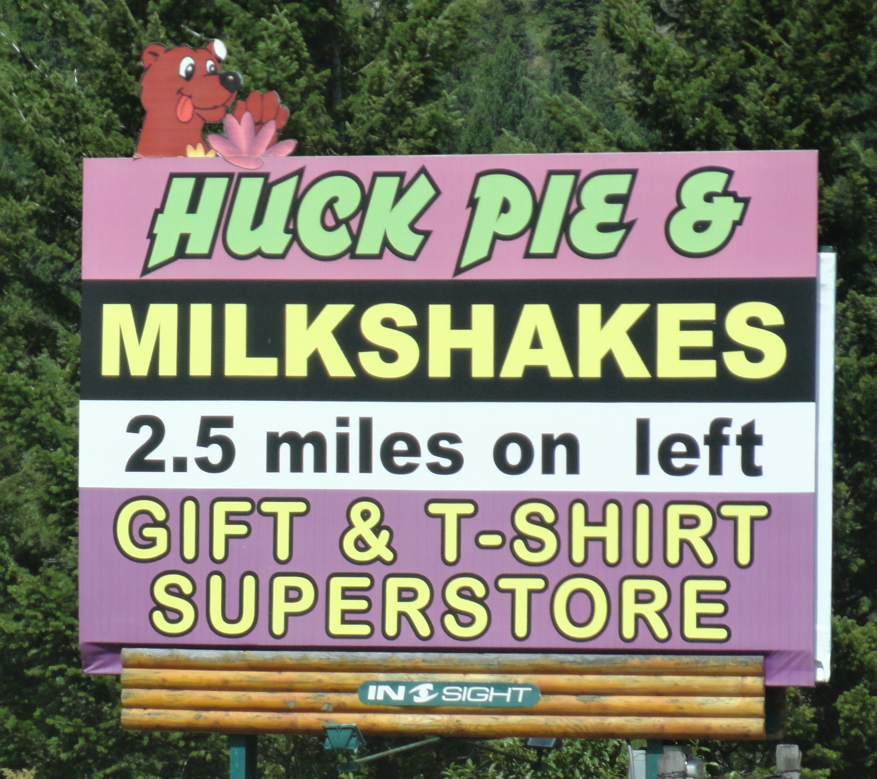
 
In case you don't have time to pick your own huckleberries while in Eureka or Hungry Horse, you will find an abundance all down the main street - everything from actual huckleberries (I brought home a pound and froze them mmmmmmmm yummy!!) to pies to milk shakes... syrups, jams, honey... Sooooo delicious!!
Pies and milkshakesJam, Pie, Ice CreamJam, Pie, Milkshakes

Hungry Horse DamWe spent one entire day at and around Hungry Horse Dam. The area is gorgeous and the dam is fascinating!
 
On the South Fork of the Flathead River, and about 5 miles from Hungry Horse town, the Hungry Horse Dam is 564 feet (172 meters) high and 2115 feet (645 meters) long.
Hungry Horse Dam
The building of the Dam (the Hungry Horse Project) started in 1948 and was completed in 1952. (According to the www.usbr.gov/pn pamphlet, President Truman "threw the switch in 1952 to start generating electricity at Hungry Horse Dam Power Plant.")
 
At the time of its completion, it was the 3rd largest dam, and 2nd highest dam in the entire world. Now it's not on the Top 10 - BUT it's still on the "tallest" list... I counted around 83rd... but I might've miscounted. (The current World's Tallest is the Nurek Dam in Tajikistan.)
 
The Hungry Horse Dam's main purposes are the generation of electricity and the control of flooding. But, it's also used for irrigation and recreation (and probably a bunch of other things.)
Down riverUp River
All dams have some sort of Spillway, which is (as per many on-line dictionaries): "A channel for an overflow of water, as from a reservoir."

Morning Glory Spillway
Official pictureBasically, though, at some point the water reaches its highest level and must be released, and the dam's purpose is to control that release of water, to prevent flooding. Most dams (that I've seen) have something like a chute. Wikipedia has a great explanation with pictures.
 
However, Hungry Horse Dam has a "morning glory" spill hole. This particular spillway (which falls under the category of "bell-mouth spillway") is the highest morning-glory structure in the world, and drops the cascading water a maximum distance of 490 feet!
 
It's called a "bell mouth" because it has a shape similar to an upside bell - when the water level reaches the level to spill over into the mouth of the bell, it funnels down into the base, and goes out through a tunnel at a lower level.
 
I've never seen this before - never even heard of it, actually.

 I was completely intrigued!
...
Sunday, we'll be talking about Seattle - just a quick trip.

Tuesday, February 19, 2013

Whitefish, Montana

Ski Lift 1Since this particular trip through Whitefish was in August, it was nice, sunny and warm. Whitefish is a beautiful little town, with beautiful scenery.
 
It’s so beautiful, ABC’s The Bachelor 2013 even filmed an episode there. (They spent their group date canoe racing, milking goats, and bucking hay*…because that’s what all Montana girls do…) (That being said, most Montana girls probably do know what “bucking hay” is… but if you don’t know, the dictionary defines it as: “is a type of manual labor where hay bales, usually 65 lb. to as much as 140 lb., are stacked by hand in a storage area such as a barn.”)
 
Whitefish is a very tourist-friendly town – and not just because it’s a world-renowned ski destination, but it also has so much to do in the summer. Even the ski hill (Whitefish Mountain Resort - also known as Big Mountain) offers a full season of summer activities, including zip-lining, hiking, and mountain biking. You can also take the ski-lift up to the summit to enjoy the summer view!
View of Whitefish Lake
 
There’s also Whitefish Lake, fishing tournaments, wine festivals, and a Huckleberry Arts Festival (this year is August 9-11), which includes a dessert back-off contest…hmmmm… I might need to plan a trip around that…)

The town itself is worth walking around (and is “pedestrian-friendly”), with it’s quirky shops with art galleries (generally local artists) and jewellery (mostly, if not all, hand crafted) stores.

So, summer in Whitefish is great, BUT it really is best known for it’s winter activities. Not only winter fishing, sleigh riding, the local dog-sledding activities and the Whitefish Winter Carnival (pay special attention – we’ve missed it this year, but it’s the 54th (?) annual, so you can plan to make it next year!), but, also! cross country and downhill skiing and snowboarding at the Whitefish Mountain Resort!Ski lift


Somehow, I had not previously gone down hill skiing, until I was about 15, when my friends, Shannan (previously mentioned) and her sister, Stacey, made me go. I was scared to death!! And, she said, “oh no – it’s really easy! You just have to point your skies down hill and then go like this” (snow-plow motion) “to slow down” and THEN! took me up a chair lift!! No, NOT the bunny hill, which is scary enough, but up a real hill!!! (Chair #3, which – ok, is called “Tenderfoot”, but don’t let that fool you!! It was SUPER STEEP AND REALLY SCARY!)

Not to mention that the Chair lift is scary enough, your first couple of times …how to disembark, how to not fall disembarking …how to not fall off on the way up the hill!! Snowboarding


So, there I am, safely off the Lift, and staring straight down the hill, straight at the Lodge, waaaaaaaaaaaay down below…I’m not sure how long it took to get down the mountain. I crawled down the first 50 feet, and then skied from one side to the other side of the mountain, zigzagging the whole way down, and when I’d get to the tree line, I’d lay down on the snow, and flip over… it was a long process.

I can’t remember if I had fun or not…

Last year, I decided to try snowboarding. But, I took official lessons at Big Mountain (they had a great deal – 2 lessons, equipment, and lift tickets, for around $70! The catch is: you are supposed to take those lessons within two days.)
Fun?
I barely could walk the day after my first lesson. I mean – not at all. I did manage to get in my second lesson. Barely. The second day was better. It wasn’t good. I am actually terrible at it. Terrible.
 
Later, when in physio therapy, they asked “Did you at least have fun?” I actually can’t remember if I did or not.. BUT, I’m at least crossing it off my list of things I haven’t tried before…
 
One of my favorite things was listening to my snowboarding instructor talking to his co-workers. “Listen – this is what I’m thinking – we should climb up on that roof, and we should board off the end, and flip around in the air and land on that roof, and then hit that mound of snow, and then go off a jump over there, and then end in that mound, and that’s when someone should take a picture of all the powder flying” (or something like that – probably really cool words, though, instead of just the basic “flip” and “jump”.) The best part, though, was the follow-up conversation: “DUDE!” “YEAH duuuuude!” “Du-u-ude”. (and all the “dude”-ing totally made sense. “TO-O-O-O-tally, Dude.”)
Snow ghosts
Peter, and the friends with us, had a wonderful time skiing. Best snow ever (today’s snow report has 85 inches (216 cms) of snow at the base) – they went through the snow ghosts, they went down the north side, they did jumps and moguls. They passed me on the bunny hill many, many times.
 
Oh! and don’t forget the Pond Skim! This year, it’s April 6. Have you ever seen this? It’s a bunch of crazy people who – well, actually, this is what the website says: “The pond skimming celebrates the wacky feeling of spring and the end of the ski season. Participants must have skis or snowboards appropriately worn (normally mounted) as they attempt to cross an 80+ foot pond…”
:D
Don’t forget to go to the Bierstube pub while you are there, and get your free souvenir ring!!!!! I got mine when I was about 15, and I’ve since lost it. They keep track, too, so you can’t get another one… :’(

See you Wednesday!  (Hopefully- this one is two days late - I had no internet!!)

Wednesday, February 13, 2013

Eureka, Montana

View of Canada from Montana45 minutes south of Fernie, and just on the other side of the US/Canada border, you will find Eureka, Montana.
Mountain ridgeOnce upon a time, people would only know "Eureka" if I added the identifying "you drove through it on the way to Whitefish" (where everyone goes skiing.) (Or if coming from somewhere other than Canada, people might have an idea where it is if I added "It's close to the Canadian border...North of Whitefish, which is north of Kalispell, which is in Montana, which is in the northern part of the United States, and no, we don't all live in teepees, and yes, we have electricity there, and indoor plumbing.")
Although, to tell you the truth, when we first moved there, even further back, in the "once upon a time" story, we didn't have electricity OR indoor plumbing. But that was just us. Well, and our neighbor. They didn't have electricity or plumbing either... and they did live in a teepee... But, I'm pretty certain electricity and plumbing were available. I'm pretty certain some people had it...?
We moved to Eureka from Seattle, again "once upon a time... a long, long, long time ago."
Montana meadowEureka was so "old west" back then, that the week we moved to town, there was an actual "shoot-out" from the rooftops, between some of the locals (can I call them "red-necks"?) and the sheriff and deputy. I don't know the cause, but a couple of years ago, I was reminiscing with my Mom, and she said that wasn't the only time that happened!
When I was in school, there was (and this is true) a bike rack AND a hitching post for those who want to ride their horses to school. It didn't get used often, but it DID get used!!
That was then... but now! people actually go TO Eureka! They go for the sake of being IN EUREKA! Can you believe that?
Having spent most of growing-up time in the Eureka area, this makes total sense to me, though. An abundance of beautiful, clear, warm lakes in the summer, never crowded. Mountains for hiking and huckleberry picking.
Huckleberry Milkshake Cafe JaxBy the way - have you ever had huckleberries? They are THE BEST berries EVER!! Generally, you can find huckleberry milkshakes, syrups, jams, pies, hand lotion and jelly beans in little stores (and sometimes even Wal-mart) all over Montana and Idaho. (Apparently, they are Idaho's Official State Fruit.)
Here's how I remember Huckleberry Picking (which I loved to do): driving way up a mountain (generally one that had, at one point or another, gone through a forest fire), climbing up a steep slope, trying to get down-wind from bears (who also love huckleberries), wrapping one arm around the huckleberry bush (so you don't slide down the shale) while holding the ice cream bucket...
My friend, Tammy, was the best-ever Huckleberry Picker. She would collect buckets of huckleberries for the day, and then she'd sell them for $20-$30 a gallon!! She supported herself a whole summer that way!
On the other hand, I would come back with maybe 1/3 of a bucket, purple stained fingers, purple stained lips, and scrapes and scratches, after either eating most of them OR dropping them all down the mountain.
Hungry Horse HuckleberriesHungry Horse Huckleberries 2Huckleberry goods
Montana's Winter Wonderland
In the winter, we have snow mobiling, snow shoeing (which I never did because I didn't "get" that it was recreational - at one point, my parents used it for a source of transportation), cross-country skiing, and down-hill skiing at the nearby Big Mountain, in Whitefish (or Fernie BC - see blog Feb 10, 2013). Oh! and dog sledding. (I only found out about this in the last couple of years, actually - after I went to my first Iditarod in Alaska (see future blog, starting March 3rd.)
Eureka is said to have the best weather in all of Montana. (Is it said by people who live in other places?) We always called it "the Banana Belt" of Montana, and now that I'm researching, I see that that's "official". The summer is almost always hot and sunny (with the best lightning storms!); the winter always has the fun snow that you can go sledding in, or make a snow man - not usually too cold to go outside - it's a Winter Wonderland! the spring is always on time, with fresh air and flowers; and fall is nice crisp air, with changing leaves. Oh! and we have Western Larch, which look like evergreens, with needles, but then the needles turn color and fall off, like leaves.
Row your boat - Lk Koocanusa
Also, since we have no pollution, you can see bzillions of stars, occasionally watch the Aurora Borealis, and/or catch a meteor shower.
Near Eureka (ok, about 45 minutes away), but "near" by Montana standards is the West Kootenai Amish Community.
Personally, I find the Amish culture fascinating! They still drive around in horse-drawn buggies. They go to school in a one-room school-house, and they speak German. They don't have electricity or telephones in their homes. They make their own furniture. They make their own candles. You can go up to the community and buy home-made goods (jams, candles, bread, and I think, quilts and furniture).
Lake Koocanusa dock 1And, my Mom tells me that nowadays, they also have an all-you-can eat dinner buffet on Friday nights. It's so popular, reservations are recommended. (It kind of makes me giggly that there's a website for this... )
Lake Koocanusa dockIf you are not completely intrigued and feel compelled to take a drive up to the Amish Community. This can only mean one thing: I haven't explained it properly...

Lake Koocanusa
So, sometime early in the 1800's, the great explorer, David Thompson came through the area, and because of the native strain of tobacco the Indians were growing, he named the valley, the Tobacco Plains. Eurekans commemorate his visit, annually in April, with Rendezvous Days, where everyone dresses like mountain men and carry muskets. (Not everyone in Eureka is a "character", but there are more than a few REAL characters - I bring this up now because:...well, if you do go to Rendezvous Days sometime in the future, you should know that SOME of the people are not in costume, but those are really just their clothes.)
Dickey LakeDickey Lake off side of boat
Officially "founded" in the 1880's by cattlemen and homesteaders, the area was first inhabited for centuries by the Kutenai Indians. In 1904, the Great Northern Railroad came through the Tobacco Valley and "the town of Eureka was born."
Eureka
Oh goodness - you have to look at this website! The town now looks almost exactly like it does in the pictures! I'm serious - I'm certain some of those buildings are still there! I know that big white building is there (or at least it was there, last time I was on that road...) (There is pavement now, and the sidewalk is concrete, too... and there's not that many horses on main street.)
Grad class
At 1037 people (as per the 2010 census), Eureka is the metropolis! Taking in the outlying areas (which were assigned to our High School area - Lincoln County High School - GO LIONS!), we include Fortine (population in 2000 was 169), Trego (no data for "Trego" town, but outlying areas - approximate population: 541), and Rexford (105 in 2010.) My graduating class had 63 kids, and we were one of the larger classes.
Well, now that I'm talking about it, I'm feeling a tiny bit homesick...
Sunday, on to Whitefish, MT.

Sunday, February 10, 2013

Elk Valley, British Columbia

Burmis TreeOH! You know what I forgot!? I forgot the Burmis Tree!! About 10 kms east of Frank Slide is this old dead tree, that looks like a giant Bonsai tree! When I first saw it, I didn’t know it was famous, but I still pulled over on the side of the road to take a picture. (It is said to be the most photographed tree in Canada, and perhaps the world!)
 
The Burmis Tree is estimated to be between 300-700 years old, and died in (or around) 19
 
It fell over in the wind (it is SUPER windy in the Crowsnest Pass) in 1998, but it is such an iconic site there, the locals propped it back up. Then, apparently some stupid loser vandals cut off a branch – SERIOUSLY? what is WRONG with people!!? – in 2004. However, once again, it was put back together.
 
It’s a beautiful tree, even dead! (http://www.crowsnestheritage.ca/attractions/burmis-tree/)
 
About…20 minutes West of the Crowsnest Pass (see blog February 3, 2013), over the GREAT Continental Divide and down the other side, is Elk Valley. Technically, Elk Valley is made up of Elkford, Elko, Fernie, Hosmer, Morrissey, and Sparwood. I can’t actually figure out where Morrissey is, so I’m not sure it actually exists anymore.
 
However, on our road trip to Hungry Horse, we drove through the other three of the other four towns, (all but Elkford).
 
Terex Titan The first town after the Continental Divide (see blog February 6, 2013) is Sparwood. (From there, you can either go west-north to Elkford, or south, to Fernie.)
 
Sparwood truck Sparwood, British Columbia, is a coal mining town, and is right on the highway. You’ll recognize it because it’s the home to one of the World’s Largest Truck – the 1974 Terex 33-19 Titan. You can’t miss it!! It’s 350 tonnes, and 66 feet (2o meters) long. It’s almost 25 feet (7.57 meters) wide, and about 22 1/2 feet (6.88 meters) high with the box down.
 
Apparently, two Greyhound buses and 2 pickup trucks can fit in the box, at the same time! (In this picture of the full truck, you can just barely see me – I’m sitting in the wheel, and Peter’s standing beside me…and in the close-up picture, you can see Peter and a friend standing underneath the truck.)
 
Coal Mining residueApparently, the Titan was the only 33-19 Titan ever made, and was made in 1973, specifically to be used for coal mining in Sparwood. Technically, it was supposed to be just the first one, but because of the economy, the industry had to use smaller vehicles instead.
 
As you drive through the area, you can see evidence of the coal mining – the mountains have been carved and mined, and are starting to grow grass again. That’s just from the road. You’d have to drive back towards the Mines to see more.
 
AND, you can actually take tours of the Mines, too. (http://sparwood.ca/visitors/activities/mine-tours)
 
Hosmer MountainBetween Sparwood and Fernie, is Hosmer. Hosmer was established as a train station for CP Railway, in 1906. But, what I always think about when I’m in the area, is Hosmer Mountain.
 
From the front (from Fernie), Hosmer Mountain looks just like a St. Bernhard dog. (Similar to Turtle Mountain, the older parts of the mountain are at the top and the younger parts are at the bottom…I have to research that more, I think…)
 
In the evening, on sunny days, though, the “Ghost Rider” legend appears – it’s a shadow on the face of the mountain that looks like the shadow of a horse and rider, with someone on foot beside them, going up the hill.
 
http://www.ourfernie.com/the_ghostrider_0 explains that it’s ”an angry Indian Chief and his jilted daughter pursuing William Fernie… that William Fernie was courting an Indian Princess to learn the source of her sacred black stone necklace…that after learning the secret location of the Morrissey Coal Seams” Fernie dumped the Princess. (There’s more about curses and luck, but I don’t really want to get into that.)
Fernie's Alpine Resort
I heard the story slightly differently – tragic, and similar, but without the curses and luck… just a sad daughter and her daddy who loves her and comes to bring her home. (I’m sure the official site is the legend, but I really like my version.)
 
Anyway, check out the shadow! You will see it!
 
15 minutes south is Fernie.
 
Fernie’s claim-to-fame is, of course, Fernie Alpine Resort. (http://www.skifernie.com/)
The Bowl
Once upon a time, I lived in Fernie, and all I can really remember now is: they have the best snow bowl, for powder, and the Griz Inn (to which you can ski or board coming down the Mountain) had the best Long Island Ice Tea. (That being said… the first time I had the Long Island Ice Tea, I thought it was actually ice tea…I didn’t know there was alcohol in it
(http://www.drinksmixer.com/drinkrq17701.html)
…now that I know better, I have to give the trophy for the Best-Ever Long Island Ice Tea to our friend, Calvin.)
 
At the time, my roommate was an expert (and completely fanatical) skier. She would spend all summer preparing her core for winter. She was a Double Black Diamond girl. I was more of a … Blue Square…girl. Ronda thought her day was successful if she was in the air more than on the snow, and I thought it was a successful day if I made it all the way to the bottom of the hill without falling. http://www.wispresort.com/wisp/info/w.beginners-trail-symbols.aspx
 
(Incidentally, I met Peter in Fernie, while he was on a ski trip :) )
 
Leaving Fernie, you get to go through a tunnel – it’s a short tunnel, but I do love it. It means that you have 3o approximate minutes before you get to the US/Canada border. Watch for the Mountain Sheep just on the other side of the Tunnel!
Mountain GoatsMountain Goat babies
Saturday – Eureka, Montana!

Wednesday, February 6, 2013

The Continental Divide?

Driving from Fargo towards Minneapolis MN, somewhere by Fergus MN, there’s a sign that says "Continental Divide" (technically would be in the range of my blog of October 9, 2012)...
What is a "Continental Divide", you ask? The dictionary definition is: "The dividing line for a continent that determines into which ocean precipitation will eventually flow." Basically, to which ocean will all rivers and streams run.
IF you are from the Rockies, you know where the Continental Divide is, and it’s not in Minnesota...
The first time I crossed the Continental Divide (and noticed) was years ago, going through the Crowsnest Pass (for more on the Crowsnest, see blog February 3, 2013), between B.C. and Alberta. Having lived my whole life on the west side, where the watershed runs to the Pacific Ocean, I was stunned to see the water running the other direction - it looked like it was running uphill!!
Now that I’ve lived about the same amount of time on the east side of the Continental Divide, the water looks like it’s running uphill when I cross over to the west side...could be time to move...
But that’s the Rocky Mountains...what’s in Minnesota?
So, I looked it up - and probably most of you (or, at least some of you) know this, but if I knew it, I’ve forgotten. The Continental Divide in the Rockies is The GREAT Divide (of course it is) which separates the watershed between the Pacific and the Atlantic (including the Caribbean Sea and the Gulf of Mexico.) The Great Divide runs from all the way from northern Alaska to Patagonia and Tierra del Fuego, following the mountain ranges of The Rocky Mountain Range AND the Andes!!!
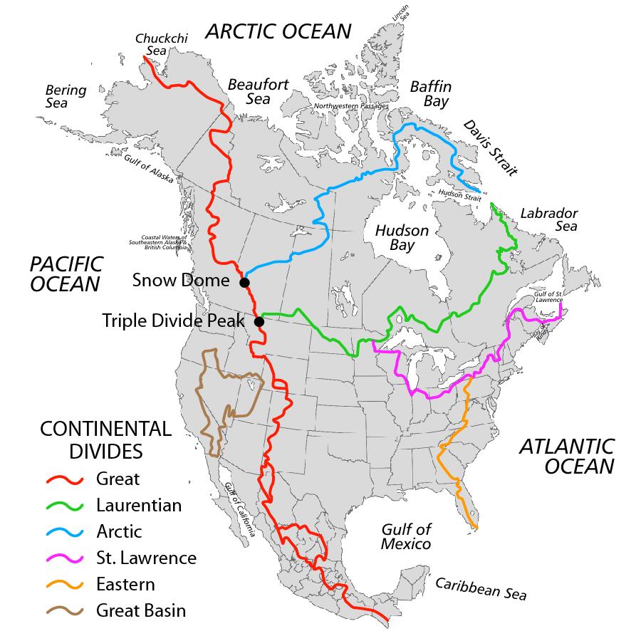
However, in North America, there are SIX Continental Divides. The one we crossed over in Minnesota is called the Laurentian, Northern Divide, or Hudson Bay Divide. It separates the watershed between the Arctic Ocean through the Hudson Bay and the Atlantic Ocean...

Incidentally, this is the same Divide that makes the South Saskatchewan River (see Blog date Sept 26, 2012) run north...which makes sense, now that I think of it...


One more point about this particular Divide - it meets the Great Divide at Triple Divide Peak in Glacier Park, MT. How did I not know this !!??? (It runs from Triple Divide Peak to the Labrador Peninsula at the Hudson Strait.)

(The other 4 North American Divides are
    North America Continental Divides
  • the Arctic ~ which meets the Great Divide at Snow Dome (which is a mountain in the Columbia Icefield (future blog), on Alberta/British Columbia border) to the Oikiqtaaluk Region, Nunavut, at the Hudson Strait. The watershed runs north to the Arctic Ocean and south to the Pacific and Atlantic Ocean.
  • the St. Lawrence ~ which runs from just north of Hibbing, Minnesota to Cape Breton, Nova Scotia, at the Gulf of St. Lawrence. The watersheds (I think - I've been having some trouble pinpointing this one) are the Atlantic and the Gulf of Mexico...
  • the Eastern ~ runs from the north of Pennsylvania, to the southern tip of Florida, and follows the Appalachian Mountain Range from Pennsylvania to Georgia. The watershed runs either into the Gulf of Mexico, the Atlantic Ocean or the Gulf of St. Lawrence.
  • the Great Basin ~ is the western continental divide. this one is actually a semi-round (not round at all, but the start and the end are the same place, so I don't know how to describe it - ...see map, attached, as per wikipedia http://en.wikipedia.org/wiki/Continental_divide). Apparently, the watershed is the Pacific Ocean, the Gulf of Mexico...and waters that "lose themselves in the Basin". (The Great Salt Lake is one of the places in which the waters lose themselves, with the Basin.)
Rocky Mountains
Every continent except for Antarctica has a continental divide.

Huh. I learned more than I expected this time. How about that!

OK! Sunday, on to Fernie, British Columbia.

http://www.uwec.edu/andersrn/Triple_Divide_Pts.htm
http://en.wikipedia.org/wiki/Continental_divide

Sunday, February 3, 2013

Frank Slide, Crowsnest Pass, Alberta

Hungry Horse DamOne of the greatest things about Alberta, is that there is an official long weekend almost every month! Some Long Weekends are more popular than others - like the May Long Weekend...and the August Long Weekend... and the February Long ... ok - really, we love them all!!
 
BUT, the good thing about the August Long Weekend is that it's always hot and sunny! (At least where WE go - I'm just saying that part for all my friends who spent last August Long in the rain...sorry).
 
We decided to go camping in Hungry Horse, Montana, with some long-time friends.
 
The BEST route from Calgary to Hungry Horse is through the Crowsnest Pass and Fernie, BC. However, for some reason, Google Maps goes a different way... OUR trip (through the Crowsnest took about 4 1/2-5 hours.. our friends followed Google, and their trip took them NINE HOURS!! (They went over the Going to the Sun Highway...
Google THAT! 
http://www.nps.gov/glac/planyourvisit/goingtothesunroad.htm and http://visitmt.com/listing/categories_NET/MoreInfo.aspx?idrrecordid=9646)
 
Anyway - we went the right way - through the Crowsnest Pass.
Train going through Crowsnest
The most obvious point of interest going through the Crowsnest is Frank's Slide. Even if you don't know WHAT it is when you are going through, you still definitely know that Something important happened there.
 
"On April 29, 1903, at 4:10 a.m., 82 million tonnes (30 million cubic metres) of limestone crashed from the summit of Turtle Mountain and buried a portion of the sleeping community of Frank in the valley below."
 
Sadly and tragically, an estimated 90 people (of the 600 inhabitants) were killed. It's an estimate, because most bodies could not be recovered. (The rocks are between 50-150 deep/15-45 meters deep).
The area that broke off was approximately 1 kilometer (0.6 miles) wide, 425 meters (1,400 feet) high, and 150 meters (500 feet) deep - approximately 82 million metric tonnes (9o million tons) of rock. The article says that, to put that into perspective, this means that if you took the fallen rocks and put built a wall 1 meter wide & 6 meters high, it would reach from Victoria, BC to Halifax, Nova Scotia (from sea-to-shining-sea), which, according to Google Maps (and we've already discussed its choice of routes) is approximately 6,145 kms/3,818 miles.
 
Roar from the slide could be heard as far away as Cochrane AB (200 km/120 miles away). People closer to Frank (or on the other side of town) reported that the sound of the slide lasted about 100 seconds, and based on how far the rocks extend, the article says that "scientists estimate that the rocks were moving at speeds up to 120 km/hr (70 mi/hr)"!!
People on rocks - size comparison

When you see it, and consider how it's even possible (the deadliest landslide in Canadian history) for that many rocks to travel that far, or to even fall to begin with.
Well, there was a LOT going on with that mountain (which, as I mentioned, is called Turtle Mountain).
 
Apparently, it's called Turtle Mountain because, before the Slide, it was shaped LIKE a turtle, and not because it's moving slowly. (By the way, there's another mountain nearby that is also shaped like a turtle, and I'll probably include that picture...but it's not THIS Turtle Mountain.)
 
But, speaking of moving slowly... the Alberta Geological Survey has started monitoring the Mountain's structure and (in)stability, in order to provide the residents living below of any future "catastrophic avalanches" as well as to " understand the mechanics of slowly moving rock masses."
(http://www.ags.gov.ab.ca/geohazards/turtle_mountain/index.html
 
I guess, looking back, it's obvious that the Mountain, in 1903, was completely unstable. Many MANY things contributed to the Disaster, among which are (in summary):
  • "The previously horizontal layers of sedimentary rock had been folded during the mountain building process until almost vertical" - you've seen it when in the mountains, right? the layers of rocks - I'm going to include a few pictures of mountains near Jasper (Alberta) that have been folded, too, but, only to about a 45 degree angle.
    Jasper area 3Jasper area Jasper area
  • The Turtle Mountain Thrust Fault runs through the mountain. THROUGH! (A "thrust fault line" is a type of break in the earth's crust, in which (by my understanding) lower rock layers are pushed up and over higher rock layers...which often means that older rock layers are then layered above younger rock layers...)
  • There's no way for me to explain this one, except by exact quote from the http://www.history.alberta.ca/frankslide website: "The erosion by water and ice of sandstone and shale layers on the lower half of the mountain beneath the older layers of limestone on the upper half of the mountain created a significant overhang. Large surface cracks along the summit of the mountain allowed water to enter deep within Turtle Mountain . Water continued to eat away at the limestone and the freezing and thawing action of water and ice worked to widen the cracks, creating even more instability." (I'm sorry - all of my attempts to summarize, were just the same exact words in different orders...if this doesn't make sense - email me, and I'll try to explain.)
  • and finally, on top of ALL of the above - vertical sedimentary rock, a fault line, erosion... they decided, in 1900, that it'd be the perfect location to mine coal.
So, the situation is: The Mountain is still vertical, there is still erosion, AND there is still a town beneath it, in which people live...
Camping nearby
We've been in the area, camping (possible topic of a future blog, because it's a beautiful site - a few miles to the West), at night, when everything is really still... and there isn't even wind to disrupt the silence... somewhere, at some time, a giant rock will roll down the nearby mountain, and I can tell you first-hand - IT CREEPS ME OUT!!!!!
 
Turtle Mountain continues to move, "they" say, by a few millimeters a year, toward the northeast, toward the valley below.
 
This time, though, there's technology... and precedence. There are over 80 sensors on Turtle Mountain now. Scientists .. "estimate" that there probably won't be another landslide like that one... any time soon... the mountain is moving "too slow" - "Turtle-like"...
 
Clearly not August Long WeekendStill... THE MOUNTAIN IS MOVING!! LISTEN!!! "Hopefully", say they, "there's no earthquake"...

I have driven through Frank Slide probably... (without exaggeration)...maybe 250 times... and every time, I feel compelled to take pictures (and yet, I am finding very few in my collection - must label better). I always want to stop. (We rarely do stop since we are usually on our way to somewhere else, but sometimes!)

You just can't believe the size of some of the rocks! With the size and distance, it's impossible to know just how small you are and how big they are, until you are standing right beside them. (One of these pictures - the one in snow (obviously not August Long Weekend - there's me perpetuating the idea that Canada is always covered in snow)- is me and a friend beside one that really didn't look that big from the road...and, thinking it was smaller, it seemed alot closer to the road...) You should absolutely get out of your car, once in awhile, and experience this site. (I'm sure it goes without saying, but you have to remember that it's a solemn place, to be respected, like a cemetery... )
 
There's also an Interpretation Center (to which, I'm embarrassed to say, I have not yet been.) The same website gives an overview of the Interpretation Center, too, as well as additional facts and features of the Disaster of Frank Slide.
 
Tomorrow - Fernie, British Columbia.